FIREAWARE
UXR & UX Design, Data Viz, AI
Hackathon Winning Project 2019
FIREAWARE is a Girl's in Tech Hackathon winning project in 2019. FIREAWARE was developed by a dedicated team of four individuals within a 12-hour timeframe. This interactive application serves a crucial role, offering visualized maps, an AI-based wildfire prediction model, and real-time alert functionality to benefit both firefighters and campers.
Meet FIREAWARE team

The Challenge
Put out the difficulty in 12 Hours
Canada experiences approximately 8,000 wildfires each year, with human-caused fires accounting for 55% of these incidents. These human-caused fires stem from various factors such as unattended campfires, improper debris burning, equipment malfunctions, negligently discarded cigarettes, and deliberate acts of arson. Predicting and preventing fire vulnerabilities can be a challenging endeavor due to their unpredictable nature.
Our high-level goals encompassed:
- Facilitating the visualization of ongoing wildfires for a global audience, ensuring accessibility.
- Empowering firefighters with enhanced control over their resources, including time and budget.
-
Establishing a real-time alert system and an interactive platform for proactive fire prevention.
My role
As a leader within the team, I played a pivotal role in not only contributing to the drafting of the FIREAWARE business plan but also in leading the UX research and UX/UI design efforts. I provided guidance and collaboration to another designer in creating the fire prediction and interactive features of the app, while simultaneously leading and coordinating the work of two developers on the visualization map and AI prediction model.
We invested about 12 hours on the project in two days.
The app is under development by Quantaloop, one of the hackathon sponsors.
Research Process
Design by conscientious
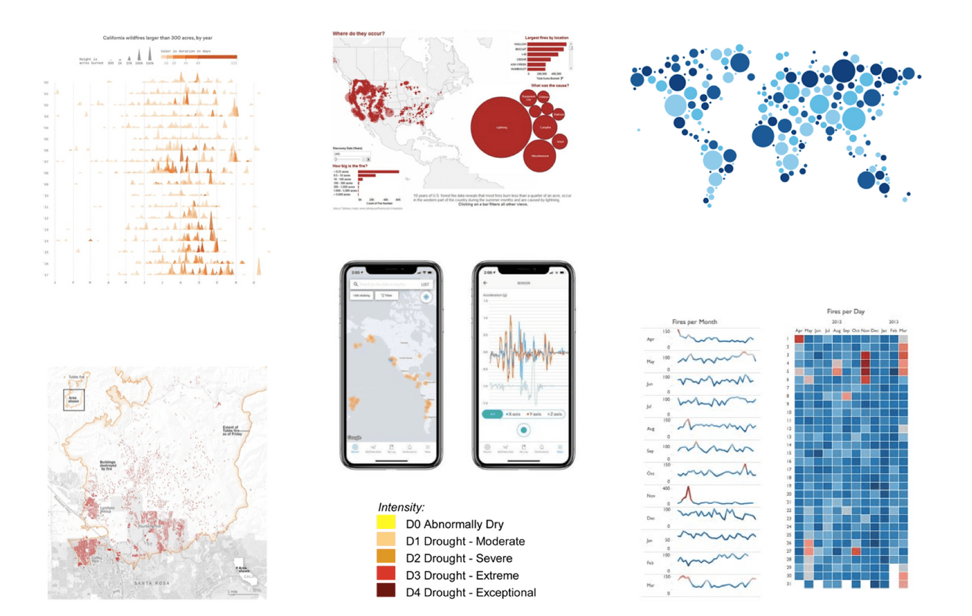
I curated a collection of visualization maps to inspire and guide my work. This process allowed me to gain insights into the most suitable map types for effectively showcasing the locations of wildfires.
User story
A good problem is the one that many thousands of people have
Wildfires have become a global concern, particularly in 2019, reaching a pandemic scale. Limited resources pose a significant challenge for firefighters in terms of both initial wildfire detection and timely response, often resulting in fires growing beyond control by the time they arrive. On the other hand, campers seeking to cook in wilderness areas face the difficulty of determining safer and less fire-prone locations on a given day. These are the target audiences we aim to address. Our market is well-defined and niche, yet it boasts a substantial user base in need of our solution.
Target User 1
Firefighters need more information to allocate resources efficiently and effectively

Meet Tom, the dedicated Fire Captain of Vancouver Fire Hall. Tom takes immense pride in his role and is deeply passionate about serving his community. However, in recent times, he has encountered challenges in managing manpower efficiently due to the escalating frequency of fires.
Tom is actively searching for an alert system or app that can provide valuable insights on areas at higher risk of fires, enabling him to strategically allocate his firefighting team for maximum impact.
Target User 2
Campers don't have enough knowledge to camp safely

Meet Lisa, a spirited student from UBC who thrives on outdoor adventures and cherishes camping trips with friends, especially during the summer months. However, she has become increasingly concerned about the growing incidence of wildfires in recent times.
Lisa is in search of a fire alert app that can provide her with essential information about her chosen camping locations, including important safety precautions and tips to prevent fires. She seeks a reliable companion to ensure her outdoor experiences remain both enjoyable and secure.
Information Architecture
The structure provides visualization map, fire alerts, educational info and user settings
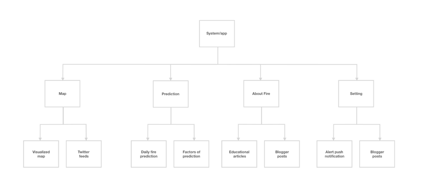
user flow
Seamless experience to get the first-hand information

VISUALIZATION MAP
Locate the wildfires timely to act accordingly
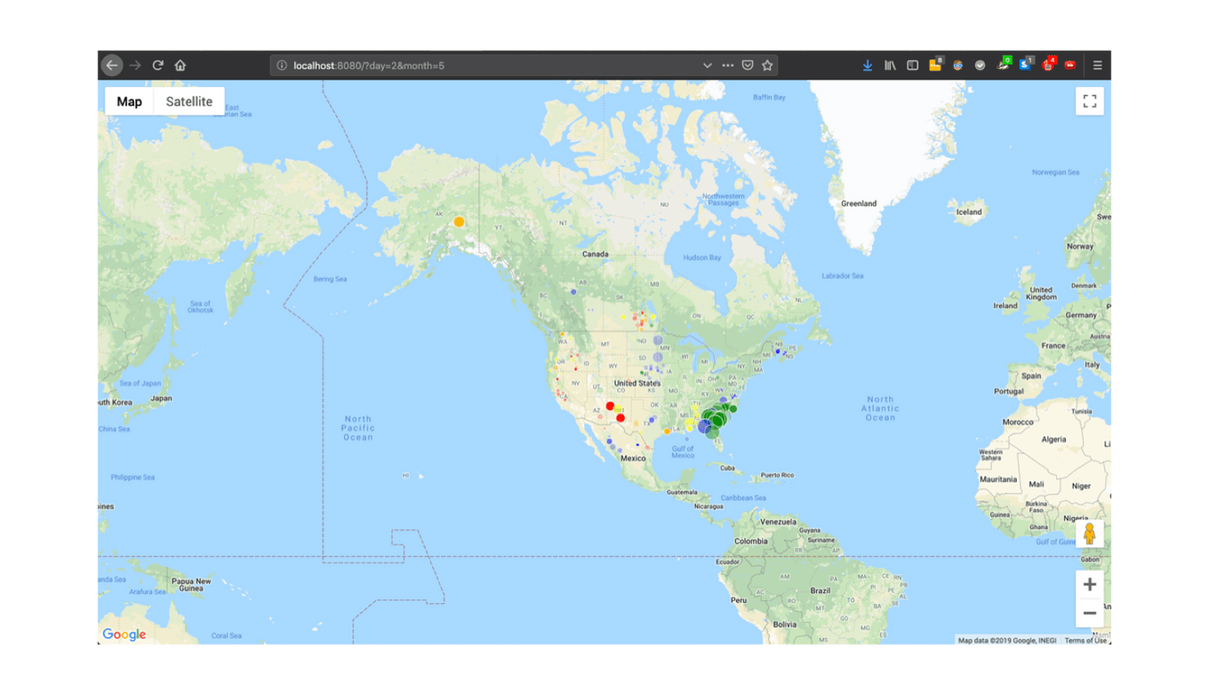
This visualized fire data is derived from NASA’s satellite imagery. Users can select a specific day and month of interest. On the map, circles are displayed in proportion to the fire’s size, with their color indicating the fire weather index. This tool provides historical information about past fires on a selected date, offering valuable insights into wildfire activity.
Low-Fi wireframes
Start bringing it to life
My approach involves sketching and whiteboarding ideas and processes in collaboration with my teammates. Given my prior experience with various existing designs, transitioning into high-fidelity designs at a later stage was a seamless process.
Final design
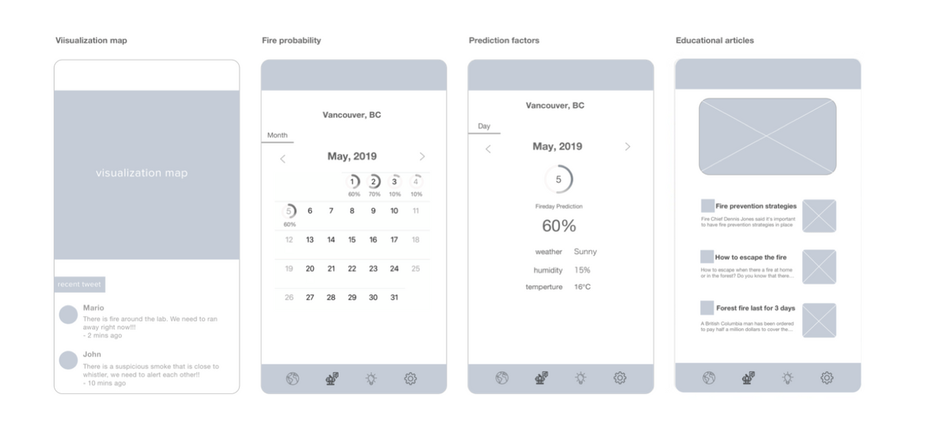
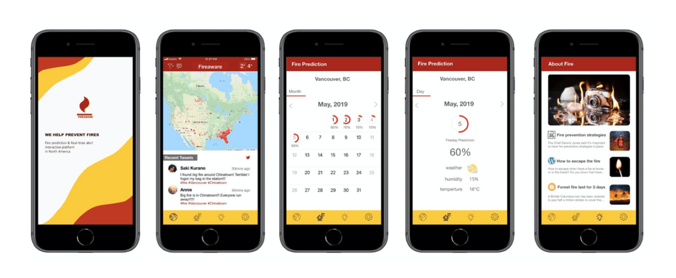
The below shows some of the app designs for FIREAWARE.
When it comes to testing an idea, prototyping emerges as the most effective method. It becomes imperative to gather feedback from both users and the judges to whom we presented our concept. We were delighted to discover that our initial idea received high praise and admiration.
APP DESIGN
- Upon entering the site, users are greeted with a visualization map displaying locations affected by wildfires. To provide real-time updates, we have integrated an API for Twitter feeds, enabling users to access the latest information about ongoing fires.
- The Fire Probability page presents daily fire predictions as a percentage (%) for the user’s selected location. This feature serves as a valuable tool for firefighters, enhancing their situational awareness, and also empowers users to make informed decisions, reducing activities that might contribute to fire incidents.
- Upon selecting a specific day, users gain access to detailed information regarding the factors influencing fire probability, including weather conditions, humidity levels, and temperature data. This insight helps users understand the determinants behind the forecasted fire risk.
- The Educational Page offers a curated selection of articles covering topics related to fire prevention, as well as the latest news and educational resources on the subject.